
90km Mont-Blanc 2026 Course Guide: Analysis + GPX
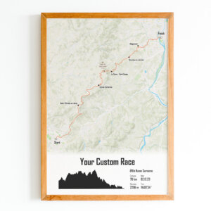
On Friday 26 June 2026 at 4:45am, 1,000 runners will set off into the Chamonix night from the Place du Triangle de l’Amitié for what is, on paper, the most demanding mountain trail race in France at this distance: 88 km and 6,200 m of elevation gain in a loop through the Mont-Blanc massif, crossing between France and Switzerland. The 90km du Mont-Blanc is not the UTMB — and that is precisely what makes it special. Accessible via ballot to runners with fewer UTMB points, it takes 1,000 participants on a high-standard alpine adventure, on trails that very frequently sit between 2,000 m and 2,500 m altitude, with sections of guaranteed snow in June. The route passes through the Brévent, the Lac d’Émosson in Switzerland, the Col des Posettes, Vallorcine, the Flégère, the Montenvers with its view over the Mer de Glace, and the Plan de l’Aiguille before the final descent to Chamonix. A complete alpine picture, on terrain that forgives nothing. The course map and elevation profile are available below.
- 📏 Official distance: 88 km (marketed as “90km”) — Loop, start and finish in Chamonix
- ⛰️ Elevation gain: 6,200 m — Very frequently between 2,000 m and 2,500 m altitude
- 🌙 Night start: 4:45am, Place du Triangle de l’Amitié — headtorch mandatory from the gun
- 🌨️ Snow almost certain on some sections in June — full alpine mountain equipment required
Key Information — 90km du Mont-Blanc 2026
Organised by the Club des Sports de Chamonix, the 90km du Mont-Blanc is the flagship ultra-trail of the Marathon du Mont-Blanc weekend. Its semi-autonomous format with 8 full aid stations, ballot access, 1,000 entry limit and tight cut-offs create a race that filters naturally. The organisation is unequivocal: a runner with an UTMB Index below 450 points has very little chance of finishing. The course record belongs to Martin Kern, set in 2021 at 10h23’11”. The first finishers of the 2026 edition are expected from 2:30pm. New for 2026: the finisher gift changes format. No more physical item — instead, each participant receives a personalised nutrition plan developed by Baptiste Ellmenreich, an elite Chamonix athlete in ski mountaineering and trail, specifically designed around the race’s aid station menu.
| Parameter | Value |
|---|---|
| Date | Friday 26 June 2026 — start 4:45am |
| Official distance | 88 km (marketed as “90km”) |
| Elevation gain | 6,200 m D+ |
| Elevation loss | 6,200 m D- (loop) |
| Altitude | Between 1,000 m and 2,200 m — frequently 2,000–2,500 m |
| Start and finish | Place du Triangle de l’Amitié, Chamonix (loop) |
| Participants | 1,000 (ballot draw) |
| Aid stations | 8 full stations + finish |
| Time limit | 24 hours per wave |
| First finishers | ~2:30pm |
| Course record | 10h23’11” — Martin Kern (2021) |
| Recommended UTMB Index | 450 points minimum |
| Semi-autonomous | Yes — strict mandatory kit + insurance for France AND Switzerland |
| Backup course | 78 km / 5,000 m D+ in case of severe weather |
| 2026 finisher gift | Personalised nutrition plan (no physical item) |
| Bib pick-up | Thursday 25 June 2026, 9am–9pm, EMC2 space — full kit check required |
| Prize giving | Saturday 27 June at 3:05pm, Place du Triangle de l’Amitié |
The Route and Profile of the 90km du Mont-Blanc 2026
The course forms a closed loop starting and finishing at the Place du Triangle de l’Amitié in Chamonix. The logic is a complete circuit of the massif via the ridges: first up to the Brévent and the Aiguilles Rouges on the western side, then crossing into Switzerland via the Lac d’Émosson, back into France via the Col des Posettes and Vallorcine, across the Aiguilles Rouges Nature Reserve to the Flégère, then into the finale via the Montenvers (Mer de Glace) and Plan de l’Aiguille before the descent to Chamonix. The course uses mountain hiking trails exclusively, often narrow, exposed, and sometimes snow-covered. The course map and elevation profile are available below.